Scratching the Surface of Warwick Township (Geology)
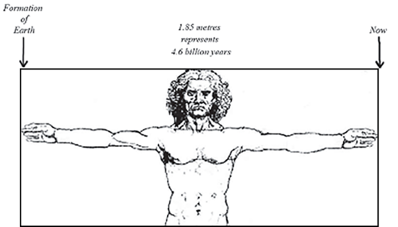
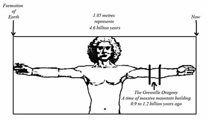
Scientists estimate the age of the earth as 4.6 billion years. Let the span of the outstretched arms from fingertip to fingertip (1.85 metres) represent that 4.6 billion years. Then one metre (m) represents approximately 2.5 billion years, one centimetre (cm) represents 25 million years, one millimetre (mm) represents 2.5 million years, and one micrometre (micron, μm) represents 2500 years. Let the tip of the left middle-finger be today and let the right middle-finger tip represent the beginning of Earth’s geologic time. Adapted from Leonardo da Vinci’s Vitruvian man.
by Peter Jensen
We residents of Warwick Township live, for the most part, on the surface of our land. On occasion we may fly over it and on rarer occasions we may explore under it, but normally our lives are confined to what appears to be a fairly flat, featureless landscape. Certainly there are some gentle ridges and shallow valleys, but they go almost unnoticed except by the farmers who have to deal with them. There was a time when roads were not much more than two muddy ruts, and then some of our hills and dales caused real problems for heavily-laden horse and wagon rigs or for early automobiles; but asphalt, road cuts and embankments and powerful engines have made those problems a thing of the past. Even Rock Glen and Hungry Hollow in the valley of the Ausable River, probably the most outstanding landscape features in the vicinity, lie outside Warwick. Unless you are from Kent or Essex Counties, Warwick Twp. must appear very flat and — dare I say it? — uninteresting. The purpose of this brief history is to change that view, to show the origins of those features we do see on the surface, and to dig nearly a kilometre and a half below the surface to reveal a fascinating history of change going back nearly a billion years.
As this history proceeds, there will be numerous references to time intervals and times in the past. I feel it is important to grasp the immensity of geologic time and, thus, to appreciate the huge stretches of time that have been available for geologic and biologic processes to occur. With that in mind, I will interrupt the narrative from time to time with an analogy to which we, as human beings, can relate.
This history then, being brief as the title suggests, will be dealing only with the last 0.9 to 1.2 billion years and will come only 36 to 48 cm up my left arm, just barely reaching my elbow. Please keep in mind then, that as this history proceeds we are moving continuously back in time from the present to the past…from my left fingertip to my right fingertip. In general, we will also be moving from higher elevations to ever-lower ones until we find ourselves over a kilometre below sea level and one and a third kilometres below the surface of Warwick Twp.
Let us look first at the surface. Warwick slopes gently upwards from the southwest to the northeast, the lowest point (about 205 metres above sea level [asl] or 28 metres above Lake Huron) being in the valley of Bear Creek where it leaves the Twp. and the highest point (about 268 metres asl or 91 metres above Lake Huron) being in the Wisbeach area just north of London Rd. This gives Warwick a total relief of about 63 metres from the lowest place to the highest. Clearly we are not as flat as we may at first appear.
Two ridges dominate the landscape. The gentler ridge, the Wyoming Moraine, occupies the northwest part of Warwick. If a line were drawn from Arkona to Birnam to Warwick Village to the intersection of Hwy 7 and Hwy 21, all the area northwest of that line is part of the Wyoming Moraine. The moraine runs generally northeast to southwest through the township, with Forest sitting on its northwest edge. The higher and more prominent ridge, the Seaforth Moraine, curves in from Middlesex County in the Wisbeach area, trends southeast to northwest for a bit, and then hooks sharply south, then southwest to Watford. Wisbeach Rd. runs more or less along the ridge of the Seaforth Moraine from Brickyard Line to Confederation Line. These moraines are recent features1 formed by lobes of glacial ice during advances of the Pleistocene ice sheets, which periodically covered all of Ontario from about two million years ago until about ten thousand years ago. The glaciers gouged and scraped vast amounts of rocky material from regions farther north and left some of it behind as ridges when they melted. The material making up the moraines is called “till ” and consists of a mixture of particles from fine clay to large boulders. A large boulder of a rock type not found in this region is referred to as an “erratic”, and some of these are used by local residents as ornamentation for gardens or markers for driveway openings.
During the Pleistocene (the epoch, or time period, commonly known as the “ice ages”), the ice in our area may have been as thick as three kilometres. Imagine the weight of a layer of ice six times as thick as the CN Tower is high! This would produce a weight the equivalent of four fully-loaded gravel trucks with pup trailers pressing down on each square foot of Warwick's surface. That tremendous amount of pressure pushed Canada's surface down into the viscous mantle of the earth; when the ice melted away, the land began to rise slowly again in a process known as “isostatic rebound”. Picture in your mind an empty canoe floating in a lake of thick molasses. If you step into the canoe, it will slowly sink a bit. Once it has reached its new flotation level, step out of the craft and notice that it very slowly rises up out of the molasses and returns to its former level. That very slow rising is what has been happening, and continues to happen to a small degree, in Warwick's region of Ontario. This isostatic rebound has had profound effects on the levels of the Great Lakes over the last ten thousand years or so.2
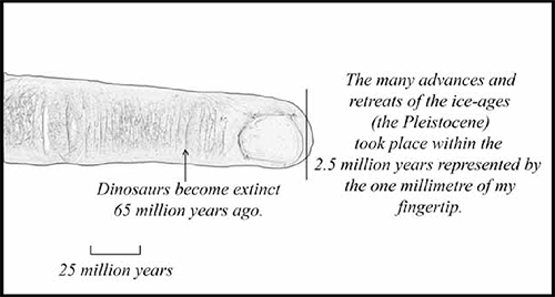
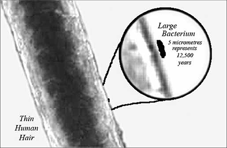
Imagine a human hair sitting on the end of my tip and then imagine a single large germ stuck to the hair. The diameter of that bacterium represents 125 centuries. Twelve thousand five hundred years (5 micrometres or 5 µm on my armspan) is roughly the time since the last lobes of ice began to melt away from Southwestern Ontario. During this time, humans developed an agricultural lifestyle, supplanting for many people a former hunter-gatherer economy. It was about five thousand years ago (2.5 µm) that humans began to develop cities and monotheistic religions.
The Western world generally uses a calendar that starts only about 2000 years ago (0.8 µm). So we see that our entire recorded history is only a miniscule distance, the diameter of a germ or a yeast cell, smaller than a red blood cell, sitting on the very tip of my finger (in this case lying on a human hair at my fingertip).
The entire Pleistocene Epoch, during which the ice sheets advanced and retreated a number of times,3 was a little over two million years long. That represents only 0.8 mm of the tip of my finger. This is about the length of a closely clipped nail, or the thickness of eight pages of this book. All of our glacial history, and therefore the formation of our entire surface physiography, occurs in that tiny distance.
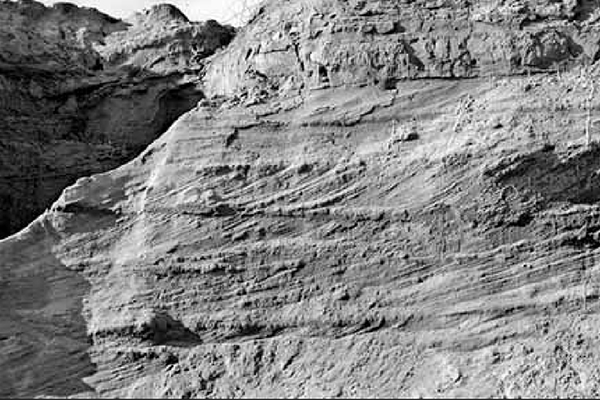
 As the snout of a glacial lobe melts back, a “pro-glacial lake”, i.e. a lake formed in front of a glacier, forms from the meltwater in the isostatically-depressed basin left by the melting ice. These lakes will leave evidence of their former existence in the form of shoreline bluffs and beach deposits along semi-submerged hills and ridges left by the glaciers, as well as sand, silt and clay deposits on their former bottoms. As the glaciers melt away, new lower outlets for the meltwater may be revealed and lake levels can drop to lower levels rapidly. Similarly, either “isostatic rebound” or a temporary re-advance of the ice front can block an outlet and lead to rapidly rising lake levels. Changes like these have led to the existence of numerous lakes of varying levels in our region and a number of different exit routes to the sea. Of the many pro-glacial lakes4 which occupied our region, three of them directly affected Warwick's surface features. These three enormous lakes, which no longer exist, are, from oldest to most recent, Lake Arkona, Lake Whittlesey, and Lake Warren. If we list them from highest to lowest by elevation of their surfaces above sea level, then the order changes to Lake Whittlesey, Lake Arkona, and Lake Warren.
Old beachlines formed by pro-glacial lakes appear in many places around the Great Lakes. However, the beaches we find in Warwick may not be at the same elevation as beaches elsewhere formed by the same lake at the same time. This can be confusing when doing research in one area based upon documentation from another, since lake level elevations don't appear to match up correctly. It must be remembered that isostatic rebound of the earth's surface occurs as the glaciers melt away, and that this can cause beachlines south of us to appear lower than those of the same lake here in Warwick.5
Lake Arkona
Lake Arkona6 was the first lake lying over our township once the ice retreated enough to expose Warwick. It was a large lake occupying the Lake Erie Basin and most of southern southwestern Ontario. Its surface was slightly lower than that of its predecessor, Lake Maumee, which existed south of Warwick when we were still under ice. Lake Arkona flowed out of the region via the Grand River in Michigan and eventually made its way to the Mississippi River and thence to the Gulf of Mexico. It left poorly-defined beach and shore-bluff evidence along parts of the Seaforth Moraine. Sand, silt, and gravel beach deposits run intermittently from Birnam to Churchill Rd.
The later rise of water levels to form Lake Whittlesey caused wave action and deposition to obscure much of Lake Arkona's evidence within the Twp. However, some features can be seen east of Quaker Rd. just south of Brickyard Line, east of First School Rd. just south of Hwy 402, and in the Churchill Line area between Bethesda Rd. and First School Rd. Heading west, Brickyard Line makes a pronounced dip between Nauvoo Rd. and Bethel Rd. as it descends the Lake Arkona shore-bluff near Birnam.
Lake Arkona's surface dropped intermittently (3.0 m followed by 2.6m) over time to form three stages. This prevented the lake from making a well-developed beach at a single elevation. Radiocarbon dating has set an age of about 13,600 years for the lowest level of Lake Arkona.7
Lake Whittlesey
About 13,000 years ago, the ice lobe in the Lake Huron Basin made a temporary re-advance, blocking the outlet of Lake Arkona and causing a rise in the lake level. This new higher lake is called Lake Whittlesey. Its waters eventually got to the Mississippi via the Ubly Channel on the “thumb” of Michigan, Lake Saginaw (which lay in front of an ice lobe in Saginaw Bay), the Grand River in Michigan, and Lake Chicago (which lay in front of an ice lobe in the Lake Michigan basin). If you stand on the Canadian National Railway crossing of First School Rd. and look east, you will see a pronounced rise in the tracks as they approach Watford. This gentle rise is the former beach of Lake Whittlesey and it can be found in a number of places around the Seaforth Moraine. Geologists have suggested that Lake Whittlesey dropped rapidly, to a level below present-day Lake Erie, when an outlet was revealed near Niagara Falls in the St. David Gorge area.
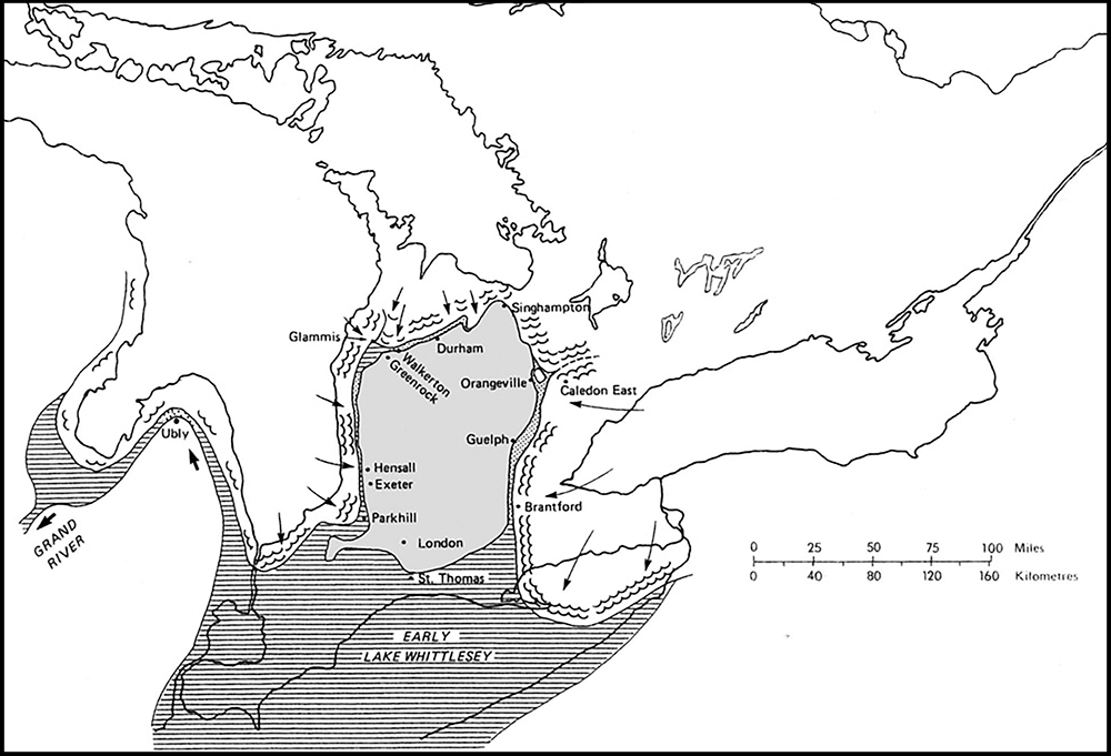
During Lake Whittlesey's time, the only part of Ontario exposed as dry land (the rest being covered with either ice to the north or water to the south) was an island bounded roughly by present-day Walkerton, Guelph, Tillsonburg, London, the higher parts of Wariwck Twp. (the Seaforth Moraine), and Hensall. Meltwater came rushing down in rapidly-flowing meltwater streams between the melting snout of the Lake Huron ice-lobe and this dry land, which is often referred to as “Ontario Island.” The streams deposited huge quantities of cobbles, gravel, and sand in our area as they entered Lake Whittlesey, slowed down and then dropped their suspended load. The sand formed sand plains such as the one found in the Warwick Village area, and clay plains farther out in the lake where the water was less disturbed, such as in the far southeasterly corner of the township between Watford and Kerwood.
This map shows the position of the ice fronts at the Port Huron Moraine System during the early stage of Lake Whittlesey. “Ontario Island” is the grey area from London to Durham. Warwick includes the little hook at the lower left of “Ontario Island”. Source Chapman, L.J., and Putman, D.F., The Physiography of Southern Ontario, 1984.
These glacially-deposited materials have a number of direct influences on residents of Warwick Twp. today. Extensive gravel and sand pits exist in northeastern Warwick Twp. at both Birnam and Arkona. Much of the quality farmland of that part of Warwick is underlain by gravel and sand which could be excavated if not for the harm it would do to the surface. Many farmers and their children have spent countless hours of back-breaking labour picking stones from the fields, as frost action and cultivation dislodge them from the glacial till and gravelly soils. The clayey soils of the clay and till plains, when combined with the flatness of the old lake bottoms, make for a poorly-drained soil in some areas. This problem can be relieved by installing drainage tiles which, until recently, were made from the very clay which was producing the problem. As well, the clay of the old glacial-lake beds was used to make bricks to build the homes of our early residents; this is the origin of the road name Brickyard Line. Fruit trees prefer good drainage of groundwater and free flow of cooler denser air when frost looms, thus the well-drained gravelly/sandy slopes of the old beach lines along the morainal edges have promoted orchard growing, another important aspect of Warwick's economy. We see, then, that there is a clear relationship between how we live today and the glacial history of our township.
Lake Warren
Another re-advance of the ice sheets blocked Whittlesey's outlet, possibly filling St. David Gorge (near Niagara) with debris, and forming a new pro-glacial lake called Lake Warren. Lake Warren, like Lake Arkona, had three stages, each at a somewhat lower level than the last: Stage II was about 3.1 m lower than Stage I and Stage III was about 1.5 m lower than Stage II. A very low-level lake called Lake Wayne existed for a time between the last two stages of Lake Warren but it had a lower water level than present-day Lake Erie and thus had no effect on Warwick Twp. The earlier stages of Lake Warren left weak, poorly-developed beachlines in Warwick Twp. running up to Warwick Village from the Hwy 22/Hwy 21 intersection, circling Warwick to the north, and then sweeping south near Kingscourt Rd. to Churchill Line. Better-developed Lake Warren beachlines appear on the northwest side of the Wyoming Moraine running from Wyoming to Forest, and on to Kinnaird and Jericho in Bosanquet Twp. Orchards and small gravel pits mark the location of the shores of Lake Warren.8
It is thought that Lake Warren flowed eastward to the Mohawk River Valley, and from there into the Hudson River and on into the Atlantic Ocean. Radiocarbon dating of organic materials in beach deposits suggests that the three stages of Lake Warren (and Lake Wayne) existed from about 13,000 years ago to 12,000 years ago.
Let me remind you again that all of the lake history outlined above occurs in a length of about 4 or 5 µm from the tip of my finger. That is about the diameter of a baker's yeast cell or of a very large bacterium…about 1/20 the thickness of a human hair. The ice ages which affected us are indeed very, very recent events!9
Today, Warwick's surface is being slowly sculpted by three major streams and a number of smaller creeks and tributaries. Surface drainage in the northeast is by Hickory Creek which flows west into Lake Huron. The headwaters of both Aberarder Creek and Highland Creek also drain into Lake Huron from western Warwick. In the southeast, Brown Creek flows south into the Sydenham River which eventually empties into Lake St. Clair. In the northeast, near Arkona, some small streams flow into the Ausable River. The major waterway in Warwick, draining the bulk of the township, is Bear Creek, which flows in a southwesterly direction into the Sydenham. All of these streams display what is termed a “dendritic” pattern; that is, the stream and its tributaries look like the roots of a tree. This is the type of pattern that arises from erosive forces when they act upon a fairly homogeneous surface such as Warwick's.
We have scratched at the surface of our township; let us now dig down a bit into the “overburden” of deposits laid down by a couple of million years of glacial ice deposition and lake sedimentation. The overburden is that material lying under our feet that has not yet been consolidated into rock. Its thickness varies widely throughout the township, ranging from 10 metres to 50 metres, as well-drilling records show. From my records I can say that near Hickory Creek Line and Elarton Rd., the overburden is 30.5 metres thick. Below that depth there is rock.
A general idea of what lies below can be obtained by examining the well-documented area under the Waste Management of Canada Corporation waste disposal site near Watford. The top six or seven metres consist of a slightly weathered glacial till. Tree roots and surface water penetration affect this part of the overburden. Only the top metre or so, which is well-weathered, legitimately qualifies as soil. Next comes a layer about three metres thick of un-weathered till consisting of clays, silts and fine sands. Below this till lies approximately a metre and a half of lake-bottom clay and silt layers, indicating a time between glacial advances when the area was covered by inland lakes. These clay layers lie upon a thin (20 cm to 150 cm) layer of coarse sand indicating more turbulent waters above. Then comes a glacial till layer approximately 20 metres thick from an earlier advance of the glaciers perhaps 150,000 to 200,000 years ago. At the bottom of the overburden lies another sand layer varying in depth from 20 cm to 1.5 metres. This sand has black shale fragments in it associated with the weathered black shale on which it sits.
Some of the clay in the overburden is often referred to as “blue clay”. At my location off Hickory Creek Line west, my well goes through blue clay from a depth of 4 metres to 30 metres. Most deep wells in Warwick Twp. pass through these clay layers.
Clay is particularly impervious to liquids and surface water does not effectively percolate down or through the blue clay; this characteristic protects deep well-water supplies from any surface contaminants from local agriculture or industry.
From where, then, does our water come? Our water comes from the “aquifer”, or water-bearing layers, consisting of the sand at the bottom of the overburden and the weathered rock surface of the black Kettle Point Shale. Many millions of years ago, before it was covered by glacial and lake deposits, this shale was exposed at the surface to the usual agents of erosion and weathering, and this broken fragmented surface acts as an excellent conduit for groundwater which flows slowly downslope from areas east and northeast of us here in Warwick. The bedrock water table in the Stratford region is 350 metres above sea level, whereas in Watford and the Arkona region it lies at 225 metres, a drop of 125 metres. At Forest, it has dropped an additional 25 metres to 200 metres above sea level. Fast groundwater takes only hundreds of years to move from recharge areas, where the surface water enters the ground, to withdrawal areas; slow-moving groundwater takes thousands of years to make the same journey. The water quality depends to some extent on how long the water has been in the ground. Old water can contain more dissolved minerals but be clear of modern pollutants, but younger, purer water is more prone to surface contamination.10
We have reached the interface between the overburden and the solid rock which lies below, and gone back in time perhaps several hundred thousand to two million years from surface to rock layer. That is hardly any time at all, geologically speaking, because in passing from overburden to rock we have now jumped a gap of about 360 million years. All the material evidence which could carry us through those few hundreds of millions of years has been eroded away. The Kettle Point Shale formation, the rock we have reached, belongs to the younger part of the Devonian Period of Earth's geologic history. A trip to Rock Glen, just outside Warwick Twp., gives the opportunity to see at first hand some of the “strata”, or layers, of the Devonian Period.
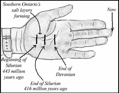
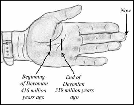
The Devonian Period stretches from 416 million years before the present (BP) to 359 million years BP.11 That 57-million-year period extends 2.3 cm from the centre of my left palm toward my wrist.
The rocks of the Devonian show evidence of the first amphibians, the development of many corals, and the beginnings of forests spreading over the land surfaces. It was also during this period that many huge oil-bearing deposits were produced. A walk through Rock Glen and Hungry Hollow will allow you to observe many fossils of Devonian life-forms, such as corals. The shales and limestones of the Devonian were formed from sediments and coral reef growth in shallow equatorial seas. That does not say that at this latitude we had a tropical climate. What it does say is that Warwick Twp. has not been sitting still on Earth's surface. Tectonic plate movement has moved us from a position near the equator and rotated us counterclockwise to bring us to our current location.12
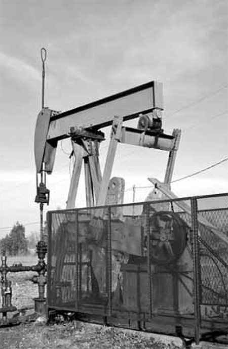
Do we have hydrocarbon resources here in Warwick? We certainly do. The main region of production is called the Watford-Kerwood Pool; it is concentrated between Confederation Line and Churchill Line, between Watford in Warwick Twp. and Kerwood in Adelaide Twp. Some oil and a lot of natural gas are removed from a layer of Devonian rock called the Dundee Formation. This formation has gentle undulations in it which act as traps to collect and hold the gas and oil. Near Forest, there is a very shallow, northeast-southwest -trending gas trap contained close to the overburden/black shale interface which allows some homeowners to have their own gas wells.
If we dig deeper into Warwick's bedrock layers, we eventually leave the Devonian Period and enter the Silurian Period. This period lasted from 443 million years ago to 416 million years ago, a duration of 27 million years. This was a time when the first land plants, air-breathing animals, and fishes evolved. When you look at the rock over which Niagara Falls flows, you are looking at Silurian rocks.
The 27 million years of the Silurian brings us 1.1 cm closer to my wrist from my fingertip.
One of the layers below us in the Silurian rocks is called the Salina Formation. It was formed from the evaporation of sea water in shallow inland seas which covered our township when it was occupying a position close to the equator. The salt layers were intermittently covered by other sediments to form other types of sedimentary rock. In the Sarnia area there are four salt layers (called Units A, B, C and D) which make up a total of 215 metres of solid salt. These salt layers extend for great distances, in varying thicknesses, to places such as Goderich, Port Huron, Windsor, and Detroit.
In the mid-1800s, salt was not produced in Canada in even remotely significant amounts. A few salt springs scattered here and there in southern Ontario produced meagre amounts of salt, which, because of its rarity, probably demanded an excellent price. Recently-discovered oil was, however, attracting the attention of many an enterprising entrepreneur. It was the drilling for oil, often unsuccessfully, that led to the discovery of salt in our county and in surrounding counties, setting off a salt boom in which the drillers now searched for salt, which had many more uses than oil and was easier to obtain, handle, and process. Some salt was actually used as fertilizer to be spread on the fields. This was probably salt from a layer richer in potassium chloride than in sodium chloride, potassium being an essential ingredient in the nutrient needs of plants.13
In 1869, a gentleman named Arthur Kingstone drilled for oil in the vicinity just west-southwest of Warwick Village. He missed the traps of the Dundee Formation and kept drilling until he entered the Salina Formation where, instead of oil, he found salt. Water, which was available from an artesian well, was pumped down into the salt formation, dissolving the salt, and the resulting brine was then evaporated over fires in evaporation pans measuring 24 m long, 4 m wide, and 30 cm deep. The brine was kept at a temperature around 85ºC to 88ºC and not allowed to boil, causing crystals to form on the surface and then sink. As the salt crystals formed, they were scraped out every four hours, allowed to dry, bagged into 45-kilogram bags, and shipped off to various markets. The plant worked two twelve-hour shifts and ran seven days a week, twenty-four hours a day. Wood was used initially for the fires but was eventually supplanted by coal. At one time a tramway joined the Elarton Saltworks, or “Saltblock” as it was nicknamed, to the Grand Trunk Railway at Kingscourt, but all traces of the station and tramway are gone now. Teams of horses with large wagons delivered the salt to local markets, but after a time trucks carried the salt to market and returned with coal for the fires. Montreal became a major market for Warwick salt, perhaps because the owner in the 1930s was a Mr. Morris Schikiranski from that city. An aerial photo from 1953 shows the Warwick Pure Salt Works to be a thriving business.14
If we dig deeper into Warwick's foundations, we pass through a series of rock layers from the Ordovician Period. This period lasted for 45 million years, from 488 million years ago to 443 million years ago. Life existed only in the seas at this time. was likely somewhat south of the equator at that time; had roads existed, Hwy 402 would be running north and south because we have rotated about 90 degrees counterclockwise since then.15 Toronto's skyscrapers are anchored in Ordovician rock.
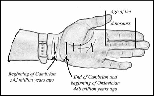
The 45 million years of the Ordovician Period moves us 1.8 cm closer to my wrist, but we aren't quite there yet.
Digging still deeper, we hit the rock layers of the Cambrian Period. Th e Cambrian ran from 542 million to 488 million years ago. Th e Cambrian rocks under Warwick consist of ancient sandstones. Although the Cambrian is generally recognized as a period of rich fossil finds, our sandstones contain no fossils.16 You would have to travel to Kingston, Ontario, to actually see exposures of these Cambrian sandstones.
The 54 million years of the Cambrian brings us about 2.2 cm farther along my hand. We are now at a position on our timeline/arm-span about 2 cm short of my watchband. Most of the lifeforms that have left fossil evidence of their existence have evolved during the time elapsed from my wrist to my tip, a time of 542 million years and a distance on my arm of 22.6 cm. We still have 162.4 cm of arm-span to go!
When we finally pass through the rocks of the Cambrian Period, we find we are about 1.35 km17 under the surface of Warwick at what geologists call an “unconformity”. The unconformity is another time gap, a place where the Cambrian sandstones have been deposited onto the eroded surface of the much older rocks which we call the Canadian Shield. The time gap in this case is roughly 500 million years, since the Precambrian rocks we are now in are 0.9 to 1.2 billion years old. Half a billion years of weathering and transportation—what we collectively refer to as erosion—has worked on whatever landforms existed here. What were those landforms?
Now that we have entered the Precambrian rocks, we have moved anywhere from 36 to 48 cm from my fingertip. This puts us at least at the middle of my forearm, or at most at my elbow. Despite being a billion years into the past, we are only a fifth of the way back to the formation of the planet Earth.
At the beginning of this discussion, I mentioned that Warwick appeared to be essentially flat. We do not associate mountains with Warwick Twp. The geologic record shows, however, that the Precambrian rocks below us are the deep roots of a massive mountain range, probably as high as or higher than the Himalayas are today. These mountains, which extended throughout southern Ontario and Quebec, formed like the Himalayas, when two tectonic plates crashed together in what is called the “Grenville Orogeny.” An orogeny is a time period of very active mountain building. The “supercontinent” formed at this time, a huge landmass composed of most of the earth's tectonic plates, is called Rodinia by geologists. Half a billion years have erased our mountainous landscape completely, but the evidence of its existence remains in the roots below us.
At the time of Rodinia's formation, Warwick Twp. was in the southern hemisphere. Some models show us at about the same latitude as Brasilia, the capital of Brazil, and rotated a full 180 degrees,18 whereas other models show us farther south at about the same latitude as Buenos Aires, Montevideo, or Santiago, and only rotated about 90 degrees.19
We now find ourselves at my elbow, still a very long way from the beginnings of our history, yet we have travelled back in time past recorded history (a germ on the edge of my fingernail), past the ice ages (a small fingernail clipping), past the dinosaurs (first to third knuckle), past the time of coal formation (the centre of my palm), past the time of the so-called “Cambrian Explosion ” when so many varied life-forms appear in the fossil record (at my wrist), all the way to the Grenville Orogeny where we find ourselves in the midst of a massive mountain range resulting from the crash between tectonic plates (my elbow).
We have only looked at about 20% of Warwick's history, but it should be remembered that the farther back we go in time, the more obscure our history becomes. As always, geologists will continue to improve their computer modelling techniques for determining age, orientation, plate movement speed and direction, paleo-climatic conditions and modes of rock formation. Exciting advances have been developed to use zircons, extremely ancient and durable mineral crystals embedded in rock, to garner information about not only the age of a rock, but also a history of its development over millions of years.20
In conclusion, we see that little is well-travelled. It has had its ups and downs, and has been on top of the world, ground to dust, hot and cold, icy and flooded, and through numerous renovations and face-lifts. The earth is a dynamic entity and will continue to be buffeted and changed over future millennia but, at the moment, we are well-positioned to avoid most of the natural catastrophes others occasionally suffer, such as earthquakes, tsunamis, rising sea-levels, hurricanes, landslides, volcanoes, floods, droughts, and desertification. What we have left, after all these goings-on, is a remarkably safe, secure, attractive, productive, and habitable landscape we call home.
Endnotes
These links were used at the time of publishing in 2008. Some links may have changed or may no longer be active.
1. I use the term “recent” because, as we shall see in this history, a few million years is a rather small interval of time from a geologist's standpoint.
2. The time period we live in, marked by the last retreat of the glaciers, is called the “Holocene Epoch.” Very approximately, we can consider the Holocene to be the last ten thousand years.
3. Glaciers, whether alpine or continental, do not retreat by backing up. They retreat by melting at their snout faster than the ice within them advances toward the snout.
4. Michigan State University identifies 27 different lake levels (with 18 different lake names) and 17 outlets (some of which are repeats) over the last 13,000 years or so. See https://www.canr.msu.edu/news/whats_up_or_not_with_great_lakes_water_levels_1
5. Th e thickness of glacial ice in Ohio, where we fi nd the far shores of our own pro-glacial lakes, would have been thinner than that in Warwick, and the ice there would have melted away many hundreds of years prior to melting away here. As a result Warwick, when it was finally free of ice yet still just in front of the glacier snout, was much more depressed than Ohio, which had already rebounded somewhat, and beaches formed by the lakes would have been on the higher bits of land here. Today, Warwick has more or less finished its rapid rebound and those beaches appear at higher elevations than the same beaches in Ohio. Stating this a bit more succinctly: a lake’s beachlines formed at the same elevation in both Warwick and Ohio, but now Warwick’s beachlines are higher because we have risen
6. These lakes of former times are frequently named after communities which today lie near or on their former shores, including Arkona, Saginaw, Kirkfield, Wyebridge, Penetang, Cedar Point, Algoma, and Dunville. Alternatively they are often named for prominent people or peoples, as in Warren, Stanley, Whittlesey, Agassiz, Lundy, Wayne, Iroquois, and Algonquin.
7. Michael C. Hansen, “The History of Lake Erie,” Ohio Geological Survey, Ohio Department of Natural Resources, 1999, https://case.edu/affil/sigmaxi/Other/History_of_Lake_Erie.pdf
8. Some years ago, when a sewer or water line was being installed along Union Street in Forest, the different layers of sand and gravel beach deposits of Lake Warren were clearly visible in the excavation cut.
9. There is no particular reason to think that the “ice age” has ended. We are currently living in what is called an “interglacial,” a time of major ice retreat. Barring some major climatic or tectonic changes, we will likely return to a time of massive glaciation again… but not in our lifetimes!
10. 2006 Thames, Sydenham & Region Source Water Protection Map Gallery, September. The Bedrock Water Table and Depth of Overburden information for this map originated with Waterloo Hydrogeologic Inc. for the Ontario Ministry of the Environment, Southwest Region Edge-Matching Study, 2005.
11. All dates regarding the earth's geologic age are derived from N. Eyles and A. Miall, Canada Rocks: The Geologic Journey, Fitzhenry and Whiteside Limited, 2007.
12. Eyles and Miall, pp. 70–75.
A fascinating account by Victor Lauriston of the salt boom in Huron County, in six installments, with references to Warwick and Lambton, appears in the London Free Press, Saturday Editions, from April 29, 1944 to June 3, 1944.
14. This information about the Warwick Pure Salt Works was obtained through an interview with Mr. Ronald Sewell, who started to work in the salt plant in the mid-thirties for $8 per week. Room and board cost him $4 per week and gasoline was 25 cents per gallon. Th e interview was conducted by Paul and Mary Janes of Warwick Village.
15. Determinations of position and orientation are geologists' best attempts to interpret many types of evidence presented by the rocks. These determinations are open to new evidence and subject to change. Geological facts arise from stone, but they are not carved in stone.
16. Information on the Cambrian rocks of southwestern Ontario was obtained by e-mail from Mr. Derek Armstrong, Paleozoic Geologist, Ontario Geological Survey, Sudbury, Ontario.
17. Th is figure applies to the Sarnia area, but it would likely be similar here in Warwick Township.
18. This can be seen in models produced by the University of Texas. See https://www.jsg.utexas.edu/research/industry-collaborations/


 Subscribe to this page